
The problem
Covering projects that cover tens or hundreds of thousands of parcels brings considerable operational challenges.
Field teams often traverse tens of thousands of parcels across isolated regions with little to no mobile coverage.
Our solution
An integrated platform tailored to large-scale mapping, data collection and processing.
Our field-tested software enables consistent and compliant land mapping and processing by eliminating operational challenges and speeding up the process.
We offer a working solution, including a software licence, setup and configuration, and a training and support package.
It performs under the most rugged conditions in the most remote regions.
First-mile data collection
You can use Meridia Survey for any necessary data point in the so-called "first mile":
farm boundaries
farmer profiles
socio-economic
traceability
land and tree rights
agroforestry and carbon
sustainability programs
the impact on, e.g. living income
Saves time
Prevent data errors from the point of entry and cleaning
Reduces cost
Executing field work and cleaning
Better geospatial accuracy
2-5x
More quality controls than usual
5-10x
"To measure and further strengthen the impact of our agroforestry program, we rely on high-quality data at farm level. Our partnership with Meridia helps us to take the next step in data collection and management and will further boost our sustainability activities."
Tilmann Silber
Global Lead Thriving Nature at Barry Callebaut
How it works
All data is collected digitally and processed in one system, from field to final dataset.
No handwritten forms, no manual file transfers.
Meridia Survey offers the ability to work with hundreds of field agents simultaneously. As many steps are automated, the risk of human error gets reduced.
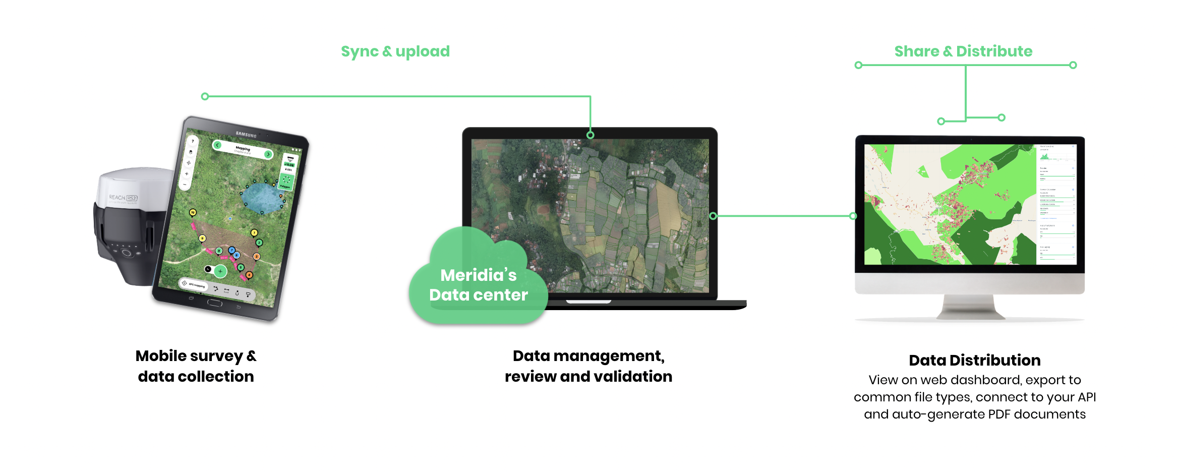
Mobile survey and data collection
Meridia Collect is an Android-based app developed by Meridia
Easy to use with minimal training
Collect anywhere, works offline and with low network bandwidth
Teams can collect data simultaneously
Simple GPS mapping or advanced differential GNSS or RTK surveying
Easy snapping to neighbouring parcels
Manage national reference pillars and base observations
See accuracy levels for each point just by their colour

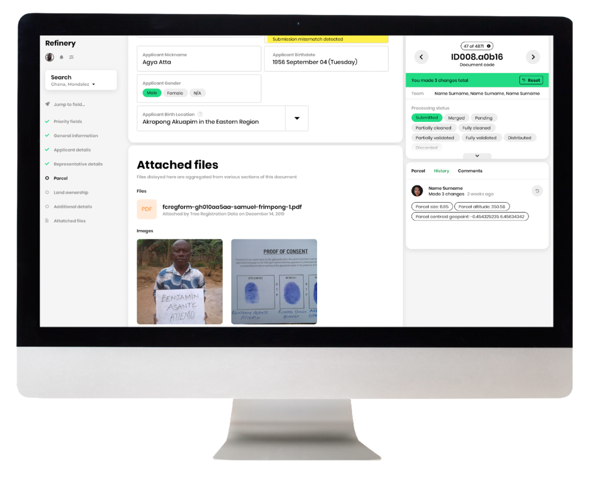
Data management, review and validation
Fix data entry mistakes and typos
Easily navigate between different sections of the file
Preview and edit attached images
Never lose your working with auto-save
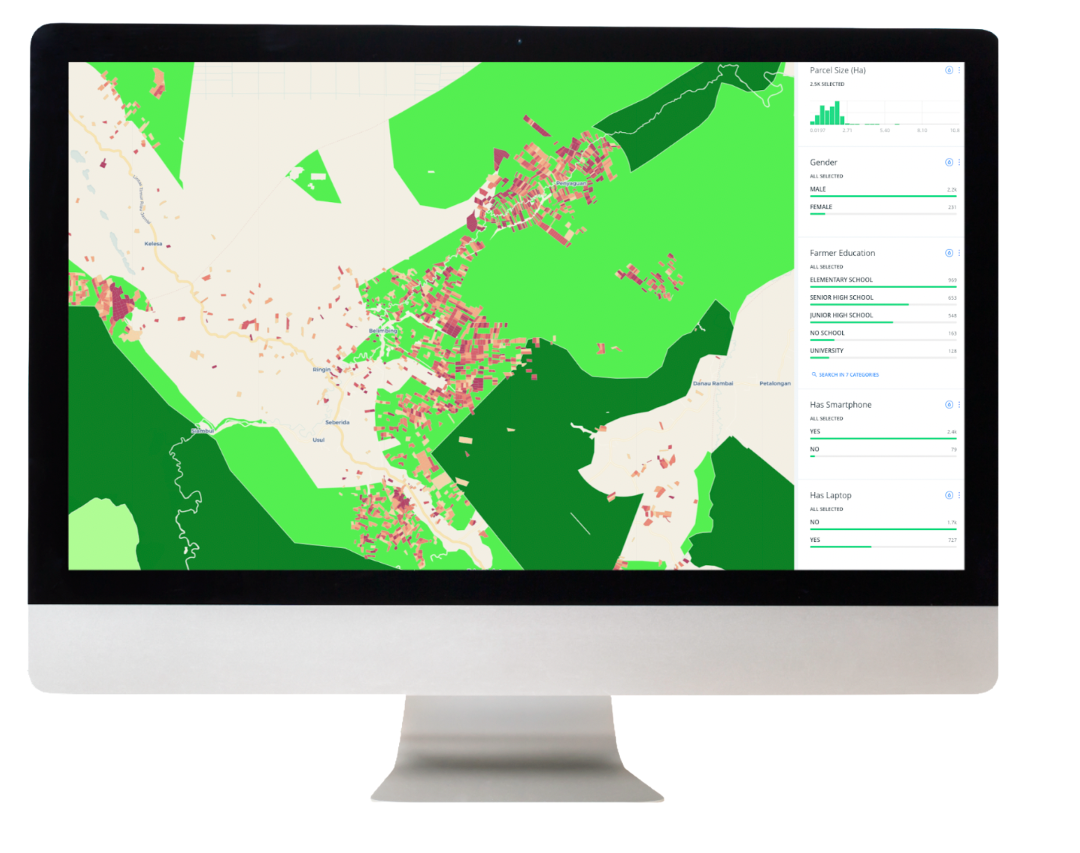
Data dashboard, visualisation and distribution
All field data visible on a single platform
Include layers from external sources (e.g. administrative areas, forests, concessions)
Dynamic dashboard to show relevant KPIs
Easy analysis without need for excel or GIS software
Dashboard graph components tailored to the specific project
Auto-generate land title PDF documents and high-quality maps
Flexible API for seamless interoperability with other platforms
With Meridia Survey, you get a working solution
1. Guaranteed working solution and ongoing support
We engage with clients to design the dataset, develop the field questionnaires and configure the workflows to ensure maximum data quality and operational cost-efficiency.
2. Contribution of expertise
We share our expertise in designing the implementation approach and data management to increase data quality.
3. Training and quality controls
Delivery of remote and on-site training approaches, coaching, detailed user manuals, and tutorials to support your staff with the mapping software.
4. Ongoing support
A 99% uptime guarantee and continuous monitoring of the technical setup. New features development and upon request. We respond within 24 hours to clients and prioritise issues and bugs.
“The quality of the maps Meridia produced is very good. It’s one of the clearest data sets I have seen, and I have touched upon many organisations in my career.”
Manuel Kiewisch
Global Cocoa Life Monitoring and Evaluation, Verification, and Learning Manager at Mondelēz International
Why work with Meridia
Go-to partner
for brands and traders serious about supply chain traceability and land tenure risks.
Technical excellence
with specialised software for high-quality data processing, allowing for speed and scale.
Expert
with a deep understanding of field reality, farm data acquisition, processing, and compliance across commodity sectors and origins.